 James Foster is a researcher at the University of Hawaii who has recently worked with a team of scientists to look into early warning systems for tsunamis by using GPS. His team recently published their research into how commercial shipping vessels can help with the early detection of tsunamis, which was then picked up by various news networks and bloggers across the world. We are lucky enough this week to have an interview with James, where he tells us a bit more about the GPS tsunami detection research as well as what plans him and the team have in the future for this application and other GPS initiatives.
1. Hi James, and thank you for agreeing to be interviewed by GPS Bites. We are really interested in your research into GPS tsunami warnings, and wondered if you could give our readers a brief introduction to your role in the study?
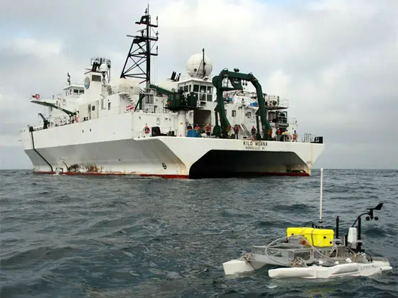
Hi GPS Bites. The study came about quite serendipitously: I had just gotten funding to upgrade the GPS systems on our research vessel, the Kilo Moana, in order to use it for marine geodetic studies.
When the news of the Chile earthquake and tsunami came in we were able to contact the ship, which had just left Hawaii to sail to Guam, and make sure that they had the newly upgraded GPS systems logging data. I then had to wait until the ship returned from a series of cruises in the south Pacific before I could get hold of the data and start looking to see what, if anything, we were able to say about the passage of the tsunami.
2. How long did it take you to complete the GPS tracking study for tsunami detection and what were the main challenges to you team when conducting the research?
I was a little discouraged when the tsunami model showed that the height of the wave at the ship was probably less than 10 cm, as that is the same amplitude and had the same approximate period, as noise I had seen in previous data sets.. It took quite some time to complete the study, both to make sure I had the best time-series of position solutions I could get, and then to work out how to pull the tsunami signal out of that and have confidence in what we were seeing.
We ended up finding that we could use the predicted wave as a filter to detect the actual tsunami signal, even though the signal to noise ratio was so poor for this relatively small event.
3. Your research certainly sounds in depth and a long process. How do you go about getting funded for your studies, and did any of the GPS manufacturers help you out with donated kit or technology?
Funding for the upgraded systems on the Kilo Moana came from the National Science Foundation. We haven’t yet approached any of the GPS manufacturers for support with hardware, but that is certainly something that we’ll be doing for the next phase of the project – especially after all the publicity that we gotten through interviews like this!
4. What kind of feedback from the academic and commercial sectors have you had so far on the Improving Tsunami Warning Using Commercial Ships study that was reported on the Geophysical Research Letters website?
The response from both sectors has been great! Commercial companies are very interested in the idea, both for the contribution they could make to society, as well as for their own improved safety and operations. From the academic sphere, tsunamis, and exploring the best ways to detect them and improve mitigation, are big topic right now, and I have had several research groups contact me interested in collaborating on moving the idea forward together.
5. NASA is also conducting research into tsunami detection using GPS by placing receivers around the Pacific. Their research is stating that the early warnings could be almost immediate, whereas your research states you could have detected the 2004 Indian Ocean tsunami in less than an hour. There seems to be quite a difference here in lead times, with that in mind does your proposed system still hold any value given the NASA statements?
Although the two projects are both using GPS, they are adopting quite different, but very complementary approaches. The NASA project is using land-based GPS to help improve the models for tsunamigenic earthquakes, as seismic data alone often underestimates the power of very large earthquakes.
Their work should help improve the initial warnings and predictions of tsunamis. Our ship-based GPS work focuses on providing more accurate observations of the tsunamis that are actually produced by the earthquakes: improving the predictions of the impact that the tsunami will have.
6. It would seem that in order to make this tsunami GPS early warning system reality that there is still some work do in order to get it adopted on commercial shipping vessels. How do you plan to make the idea become reality, or does your involvement end now that you have released the research results?
The next big challenge for us is to show that the system can work in real-time. To do that we’ll need to run a demonstration system using a couple of commercial ships. We have started contacting shipping companies to discuss collaborating on this project and expect to be able to start moving forward with it in the next few months.
I plan to stay involved as long as there are still important questions to be answered about how to make the system work operationally, and what other science might be done with the data that will be collected. Once it moves from the research and development phase, however, I expect to leave handling of the actual installation and operation of the system to someone else.
7. Are there any other exciting developments and studies that your team at the School of Ocean and Earth Science and Technology are doing at the moment which you would like to share with our readers?
Funny you should ask: we are now working on another project with the Kilo Moana to see if we can estimate the “sea state”. We’ve equipped it with a radar gauge as well as the GPS systems, so we can observe the wave field. Getting better measurements of this is important for ocean safety as well as for understanding the transfer of energy between the ocean and the atmosphere. The preliminary results are looking very promising!
Want to Know More About the Research?
If you would like to know more about James Foster from the University of Hawaii, plus the research that they conducted then please check out some of the following links which go into a lot more detail:
